Goals
- Footways that are wider and more comfortable to use
- Lower motorised traffic speeds, noise and particulate matter
- Easier crossings of the main road
- Improved comfort at bus stops
A change in thinking
We need to change the way we think about the A48 - and in particular, we need to change the way the Vale of Glamorgan Council thinks about the A48. At present, unelected highways engineers dictate how the main road functions. We need to democratise the decision-making and allow innovative solutions to the problems that we as residents of St Nicholas face because the main road through St Nicholas has been designated for the purpose of allowing as many motorised vehicles through the village, at the expense of all other functions.
Elsewhere, there has been success in accepting that a street/road has multiple types of users, and serves multiple functions.
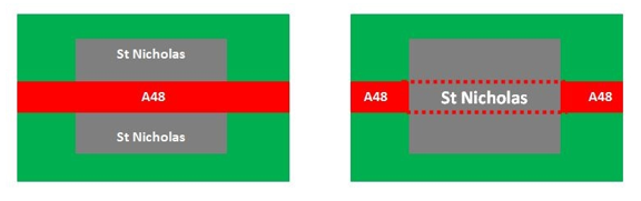
The graphic below shows how the road is currently viewed, and how it should be viewed. St Nicholas is currently in two parts on either side of the A48, however, the village should dominate the road, the A48 finishing at either end of the village, with vehicles passing through the village as "guests".
Elsewhere, there has been success in accepting that a street/road has multiple types of users, and serves multiple functions.
The graphic below shows how the road is currently viewed, and how it should be viewed. St Nicholas is currently in two parts on either side of the A48, however, the village should dominate the road, the A48 finishing at either end of the village, with vehicles passing through the village as "guests".
Consideration to the other functions of the main road needs to be given, These functions include visiting neighbours on both sides of the street, catching busses, and walking and cycling through and across the village. These activities will be conducted by adults of all ages and physical abilities and children.
As stated in the documentation for the conservation Area, the footpaths through the village are substandard, being only 1.2 metres wide - and narrowing to 0.7 metres behind the Cardiff bound bus stop in the centre of the village. To widen the footpaths, either extra land land to the sides of the road is needed, or the road needs to be narrowed.
As stated in the documentation for the conservation Area, the footpaths through the village are substandard, being only 1.2 metres wide - and narrowing to 0.7 metres behind the Cardiff bound bus stop in the centre of the village. To widen the footpaths, either extra land land to the sides of the road is needed, or the road needs to be narrowed.
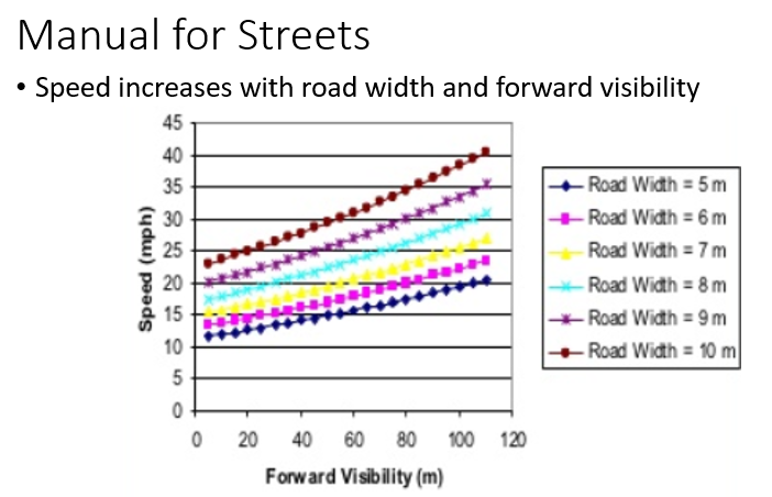
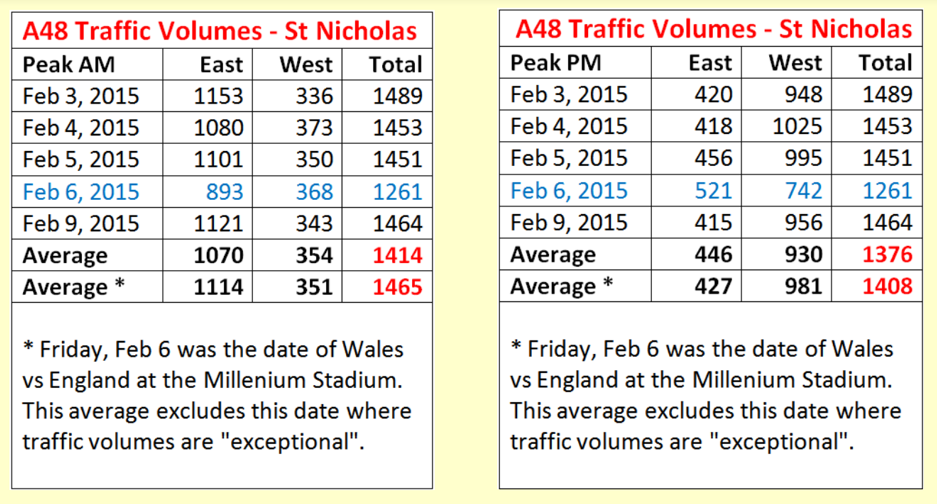
Research for the DfT's Manual for Streets confirmed that narrower roads reduce vehicle speeds. There has been a problem with excessive speeds through the village in recent years - results of speed surveys can be found on the sub page here. Whilst many would assume that vehicles are speeding due to not slowing down for the urban area, in fact the problems with speed is greater as vehicles leave the village, accelerating early due to the long sight lines ahead, particularly towards Cardiff.
|
|
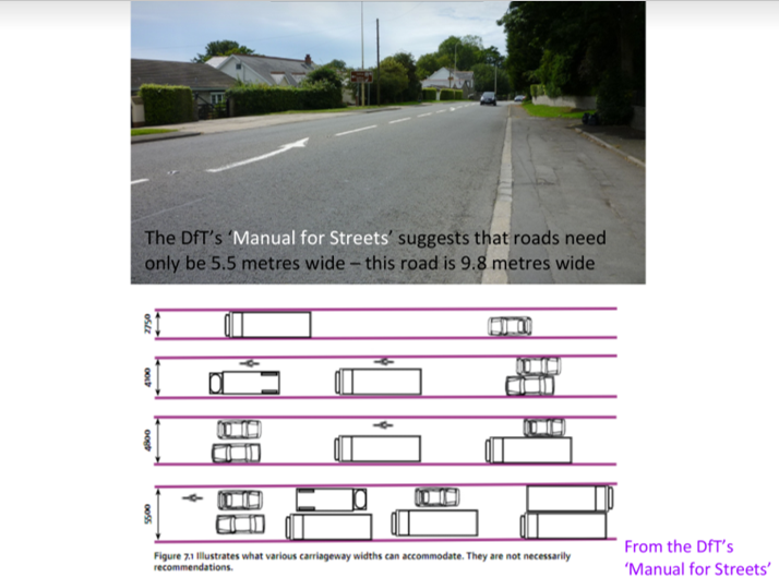
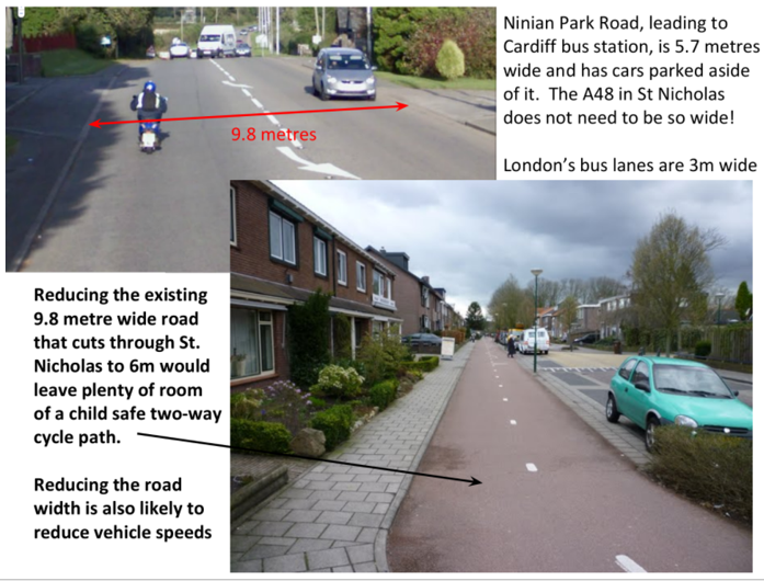
The Manual for Streets suggests that road width need only be 5.5 metres - the narrowest point of Five-Mile Lane being 5.6 metres. A 6m width would be acceptable, most bus lanes being 3m in width. Port Road in Wenvoe and Barry (A4226) has been narrowed, and the safety camera removed in recent years.
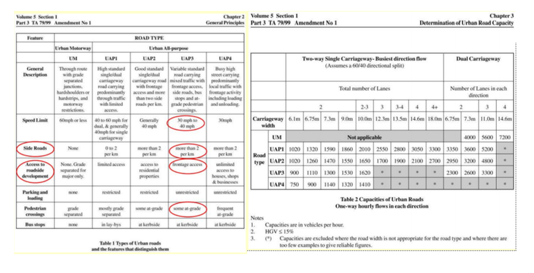
The road through St Nicholas is 7.3 metres wide at its narrowest point outside the former post office and village hall. The hill towards Trehill is 9m, and elsewhere it's around 10 metres wide. The road type is UAP3, as shown below, giving it a capacity of 1,300 vehicles per hour. Narrowing the road reduces capacity, I believe, due to increase likelihood of obstruction, such as a parked vehicle. But, as stated in the Design Manual for Roads and Bridges, the environmental benefits of narrowing the road should outweigh any delays caused by making St Nicholas a more people friendly place.
Most road capacity is determined by intersections rather than the links. So the traffic signals at Dyffryn Lane (and Culverhouse Cross) are likely to be a more limiting factor. There is no data available on the capacity of the signals at Dyffryn Lane.
Right turns into the northern half of the village reduce capacity below the figures given below.
Footways
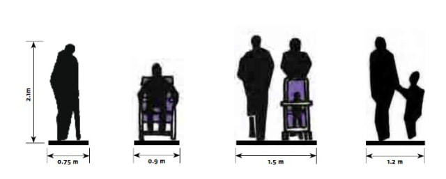
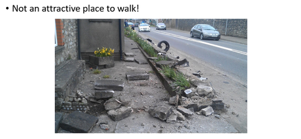
The footways through St Nicholas are just 1.2 metres wide. Barely wide enough for a parent to have a child walk by their side. The footway narrows to just 0.7 metres behind the bus stop - a width narrower than a wheelchair. The Manual for Streets gives the following width requirements for different footway users.
The lack of footway width behind the bus stop, even with no one waiting there, is a problem.
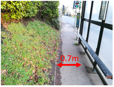
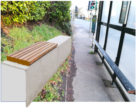
The embankment behind the bus stop is a poor use of space offering little for the environment or people. A retaining wall could be built to gain space for the footpath and make a seat for those waiting for a bus. This could be further developed into a forward facing shelter - people waiting for a bus should be able to sit looking forwards to see approaching busses.
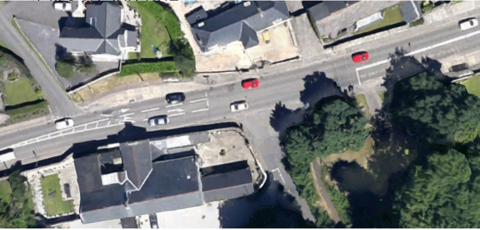
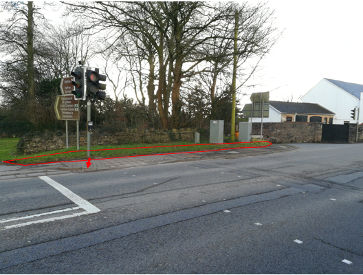
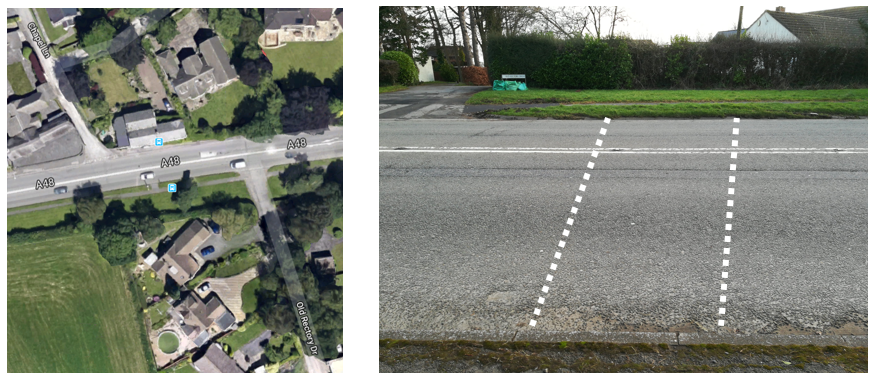
From above, the Cardiff bound bus stop and junction with Dyffryn Lane looks like this today:
Before 1990, there was no turning lane marked for turning right to Dyffryn. Then, in 1990 a vehicle driven by someone over the drink drive limit travelled towards Cardiff at 70mph through the village. A car was stopped to turn right into Dyffryn Lane. Skid marks were visible for weeks, starting by the former post office, and ending at the top of Dyffryn Lane where the speeding vehicle impacted with the vehicle waiting to tun right. As a result of this collision, a lane for vehicles turning right was marked.
The bus lay-by and stop is poorly designed. It's in an excellent position for everyone living in the existing village being within 200 metres of existing homes. It must not be relocated! There is scope to move the bus lay-by out into the road by 1 metre, removing the turning lane into Dyffryn, and reshaping the lay-by.
The expensive (£200 each) bus kerbs at the existing stop are not where the bus stops so are pointless. They are not really needed, and the highways engineers have failed to install these expensive bus kerbs correctly throughout Wales - not just the Vale. Standard kerbs cost just £5. The purpose of bus kerbs is to reduce the gap between footway and bus to 50mm and to provide a textured surface with the visually impaired. Standard kerbs and tactile slabs so the same job for less money, present no increased trip hazard for pedestrians and don't risk damaging bus tyres. The use of bus kerbs in Wales has wasted so many thousands of pounds!
The bus shelter could be better - and have a seat facing approaching buses!
By removing the lane for turning into Dyffryn, the footway can be widened to 2.2 metres and the bus lay-by and waiting area redesigned so that it is more comfortable for users.
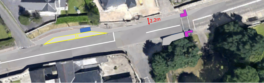
The mistake in the sketch above being that the taper into the lay-by needs to be longer - sadly this mistake can be seen in recently built bus lay-bys in the Vale. Unelected Highways Engineers are not held to account in Wales...
The footway to the south of the crossing to Dyffryn Lane can be widened onto the verge, and the traffic signals moved to the road side. A Toucan Crossing should be provided because we should be allowing children to cycle through the village. The A48 will never be a suitable for children to cycle on, mixed with motorised vehicles.
The positioning of the signals slightly away from the road reflects the narrowness of the footways - and the priority given to motorised vehicles cutting through the village..
The positioning of the signals slightly away from the road reflects the narrowness of the footways - and the priority given to motorised vehicles cutting through the village..
In the world of the unelected highways engineers, substandard provision for vulnerable street users is acceptable when maximising provision for those in motorised vehicles.
The main road is 7.3 metres wide by the former Post Office and Village Hall. It widens as it goes towards Cardiff, to 11 metres. There is plenty of room to provide a new shared foot and cycleway linking Dyffryn Lane to the east of the village and beyond...
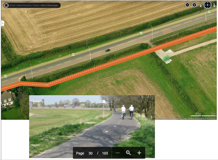
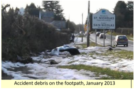
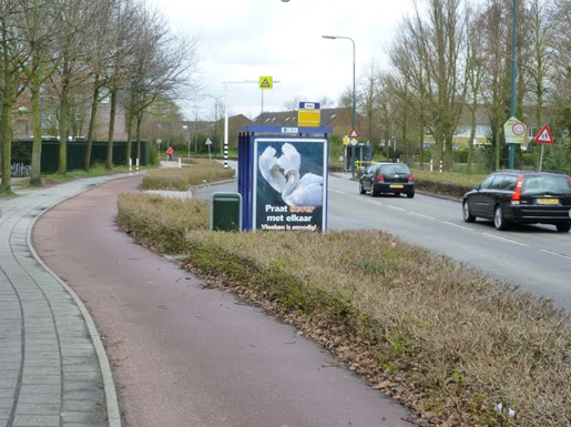
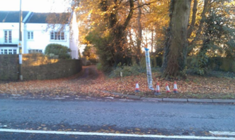
Buffering the path between St Nicholas and The Downs is important. The existing narrow path that is lower than the road suffers from air and noise pollution, and users are threatened by debris and vehicles leaving the road - as in the image below:
Towards Trehill
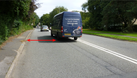
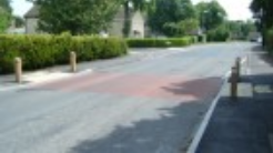
The road up the hill to Trehill is again excessively wide at 9m, with narrow footways. The photograph below clearly shows how much excess width there is - more than enough room to park, but no demand for parking.
So, the space could be redistributed as below:
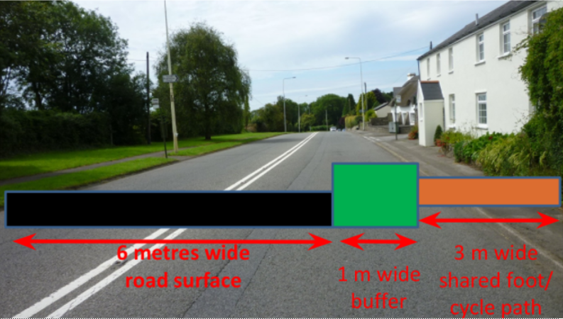
The 1m wide verge keeping children safe from traffic. It needn't be just grass that needs cutting weekly, but a low hedge/shrub. This prevents young children from wobbling into the road and is a barrier to debris and vehicles leaving the road.
|
|
New Crossings
Narrowing the road from 9m to 6m wide at Trehill would make crossing the road to visit other residents or to access or leave a bus stop or country footpath much easier and safer. A crossing should also be considered - perhaps a zebra crossing (cost £15k-£20k). Highlighting an informal, uncontrolled crossing place would cost £4k.
Perhaps highlighted informal crossings (example below) by the former Post Office to Mawsons Mead and/or between School Lane and Brook Lane would influence driver behaviour as they pass through the village, raising awareness of potential conflicts with pedestrians.
20mph
|
|
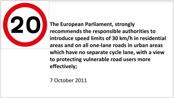
The UK is being rather slow to embrace 20mph speed limits. Clearly the small roads of the village are unsuitable for speeds of 30mph, but the speed limit here can encourage excessive speeds. 20mph can also be too fast...
There is the potential to have part-time 20mph limits on trunk roads where they are within 50m of a school. By road, our school is just over 50m from the road, but as the crow flies... Given the recent planning decisions, it seems that it's not impossible to make a case for a part-time 20mph speed limit along the A48, from the bottom of school Lane by Pwll Sarm Farm, to the new Waterstone Homes development, though some may argue that dropping from 60 to 20 to be too much, so perhaps the speed limit to Tumble Hill would have to be reduced to 50mph. There is a strong case for this 300m stretch of road, past Smiths Row and the narrow roads of the village to have a 20mph limit. Highway Engineer guidance in the UK, unlike in other countries, prioritises motorised traffic and ignores the needs of children and other street users. Whilst we've seen 20mph schemes successfully implemented in urban areas and on trunk roads in Scotland, in England and Wales they are reserved for "urban areas", and St Nicholas is classed as a 'village', not as an 'urban area'.
There is the potential to have part-time 20mph limits on trunk roads where they are within 50m of a school. By road, our school is just over 50m from the road, but as the crow flies... Given the recent planning decisions, it seems that it's not impossible to make a case for a part-time 20mph speed limit along the A48, from the bottom of school Lane by Pwll Sarm Farm, to the new Waterstone Homes development, though some may argue that dropping from 60 to 20 to be too much, so perhaps the speed limit to Tumble Hill would have to be reduced to 50mph. There is a strong case for this 300m stretch of road, past Smiths Row and the narrow roads of the village to have a 20mph limit. Highway Engineer guidance in the UK, unlike in other countries, prioritises motorised traffic and ignores the needs of children and other street users. Whilst we've seen 20mph schemes successfully implemented in urban areas and on trunk roads in Scotland, in England and Wales they are reserved for "urban areas", and St Nicholas is classed as a 'village', not as an 'urban area'.